
Riparian Buffers as a Critical Landscape Feature: Insights for Riverscape Conservation and Policy Renovations


1
Department of Biological Sciences, Bridgewater State University, Bridgewater, MA 02324, USA
2
Department of Ecology and Evolutionary Biology, University of Connecticut, Storrs, CT 06269, USA
*
Author to whom correspondence should be addressed.
Diversity 2022, 14(3), 172; https://doi.org/10.3390/d14030172
Submission received: 4 December 2021
/
Revised: 19 February 2022
/
Accepted: 20 February 2022
/
Published: 27 February 2022
(This article belongs to the Special Issue 2021 Feature Papers by Diversity’s Editorial Board Members)
Abstract
:Riparian zones are critical for functional integrity of riverscapes and conservation of riverscape biodiversity. The synergism of intermediate flood-induced disturbances, moist microclimates, constant nutrient influx, high productivity, and resource heterogeneity make riparian zones disproportionately rich in biodiversity. Riparian vegetation intercepts surface-runoff, filters pollutants, and supplies woody debris as well as coarse particulate organic matter (e.g., leaf litter) to the stream channel. Riparian zones provide critical habitat and climatic refugia for wildlife. Numerous conservation applications have been implemented for riparian-buffer conservation. Although fixed-width buffers have been widely applied as a conservation measure, the effectiveness of these fixed buffer widths is debatable. As an alternative to fixed-width buffers, we suggest adoption of variable buffer widths, which include multiple tiers that vary in habitat structure and ecological function, with each tier subjected to variable management interventions and land-use restrictions. The riparian-buffer design we proposed can be delineated throughout the watershed, harmonizes with the riverscape concept, thus, a prudent approach to preserve biodiversity and ecosystem functions at variable spatial extents. We posit remodeling existing conservation policies to include riparian buffers into a broader conservation framework as a keystone structure of the riverscape. Watershed-scale riparian conservation is compatible with landscape-scale conservation of fluvial systems, freshwater protected-area networks, and aligns with enhancing environmental resilience to global change. Sustainable multiple-use strategies can be retrofitted into watershed-scale buffer reservations and may harmonize socio-economic goals with those of biodiversity conservation.
Keywords:
riparian zones; riparian buffers; streams; rivers; riverscapes; watersheds; catchments; conservation1. Introduction
Riparian zones are influenced by hydrodynamic forces in fluvial ecosystems (i.e., lotic systems, such as rivers and streams) and represent transitional aquatic-terrestrial interphase bordering these ecosystems, and as such have numerous functions. They connect terrestrial and aquatic habitats through surface runoff, subsurface flow, and flooding [1,2,3]. Riparian zones are characterized by saturated soils, elevated water tables, and a three-dimensional configuration, which extends laterally into the river basin, vertically into the riparian canopy and groundwater, and longitudinally along fluvial channels [1,2,3,4]. Through surface and subsurface hydrologic processes, riparian buffers colligate waterbodies with adjacent uplands and govern the exchange of energy and matter between aquatic and terrestrial ecosystems [3,5]. The three-dimensional configuration, mediation of energy and matter flow, habitat heterogeneity, and the unique biotic communities make riparian zones an integral constituent of riverscapes [6,7]. The constituents and conceptual framework of riverscapes vary considerably among various disciplines of applied and foundational ecology. Lotic systems and their biota, including the spatiotemporal dynamics (e.g., species-habitat and community-scale interactions) inherent to these systems, nested within socioecological landscapes are collectively referred to as a riverscape [8,9]. While accommodating this broader viewpoint, riverscapes can be defined as spatially structured, hierarchically organized, heterogeneous habitat mosaics nested within the river continuum [10,11,12,13,14].
Natural disturbances in riparian systems enhance environmental complexity both spatially and temporally [3,15]. Through variable flow regimes, alternative erosion-deposition patterns, and channel migration, fluvial processes have sculpted riparian zones into landform mosaics with modified geomorphology and edaphic conditions [1,3]. Riparian vegetation is substantially structured by the hydrologic gradient (i.e., the variability in the duration, frequency, and timing of inundation). Interspecific differences in flood tolerance and moisture dependence produce spatial and temporal patterns in the riparian community composition and cover types along the hydrologic gradient [16]. Riparian zones have a disproportionate influence on the local ecosystem, yielding a multitude of ecosystem services, thus considered a keystone resource within the landscape [3,4,17].
Studies that have spanned across numerous global ecoregions have emphasized critical and complex functions of riparian zones, including regulation of aquatic thermal properties [3,4]; bank stabilization [1,17]; nutrient assimilation, silt and sediment retention [18,19]; groundwater recharge [3]; and input of woody debris and other allochthonous matter [1,15].
Given these complex ecosystem services and functions and extensive habitat degradation experienced by lotic systems, the scientific community has widely recognized the need for riparian zone conservation. Numerous natural-resource management and conservation authorities have implemented regulatory policies and established guidelines targeting riparian-buffer delineation. The biological effectiveness of existing policies is debatable, while such regulatory enforcement has received substantial criticism [20,21]. Existing policy standards in certain jurisdictions can be outdated, resulting in conflicts with the current scientific comprehension of riparian ecology. Originally intended to mitigate non-point source pollution, riparian buffers can be managed for wildlife conservation as well as to boost ecosystem functions [22,23]. Although the ecological role of riparian zones has been long recognized, scientific literature on riparian buffers mostly focuses on either a single taxon (e.g., fish, amphibians) or a handful of ecosystem functions (e.g., nutrient filtering, pollution remediation). We argue that a review of current literature on riparian systems will lay a foundation for a multi-taxa multi-functional focus on riparian-zone conservation, painting a holistic ecological framework to reinforce policies and regulatory actions. Many studies on riparian-buffer management are shoehorned towards specific localities or geographic regions. Thus, an overview of such region-specific approaches and their applicability across broader geographic contexts are both prudent and timely needs. In this review, specifically targeting temperate North American riparian systems, we intend to (i) explore their overall ecological benefits; (ii) discuss threats and conservation challenges; and (iii) synthesize conservation actions and policy reforms targeting riparian conservation. Our review will help conceptualize conservation potential and ecological values of riparian buffers and thereby provide a foundation to formulate novel conservation approaches to protect and manage riparian zones.
2. Riparian Buffers—A Nexus for Biodiversity
Riparian habitats represent a nexus of biodiversity where both species richness and density of wildlife are disproportionately high compared to nearby terrestrial habitats [1,24]. Many semi-aquatic and aquatic organisms, particularly those with complex life histories (e.g., amphibians), depend on riparian zones for a significant portion of their lifecycles [25,26,27]. Riparian zones in the United States account for <5% of the land area (15–50 million hectares) yet provide habitat for over 70% of vertebrate species and are thus considered a keystone habitat [28]. In the arid southwestern United States, riparian habitats account for <1% of the landscape yet are enriched with 80–90% of regional wildlife diversity [29]. Riparian zones exhibit high levels of species richness and diversity and provide habitats for numerous habitat specialists. Riparian systems can act as local refugia for species, thus serving as population sources to support recolonization of disturbed habitats, such as commercial timberlands [30,31]. Bats and birds use forested riparian corridors as flyways, foraging grounds, and roosting sites [32,33]. During the migratory season, the avifaunal richness of riparian zones is at least an order of magnitude higher than the nearby uplands due to increased foraging opportunities and overwintering sites [34]. Amphibian dependency on riparian buffers is pronounced in the Pacific Northwest of the United States, where 47 species are either obligate or facultative stream associates [35]. Many turtles are particularly dependent upon riparian buffers for dispersal, foraging, hibernation, and oviposition. Floral biodiversity, particularly bryophytes, pteridophytes, and herbaceous plants, is remarkably high in riparian buffers [36]. In northern hardwood forests, native vascular plant richness in riparian forests was remarkably higher compared to upland, interior forests, while invasive and ruderal species were less frequent in the former [37]. Marked floristic species turnover rate (beta diversity) between riparian buffers and adjacent uplands heightens species complementarity along the aquatic-upland gradient, which also generates a greater landscape-scale species richness (gamma diversity) [15].
3. Riparian Zones—Ecological Functions
3.1. Reciprocal Energy and Matter Subsidies
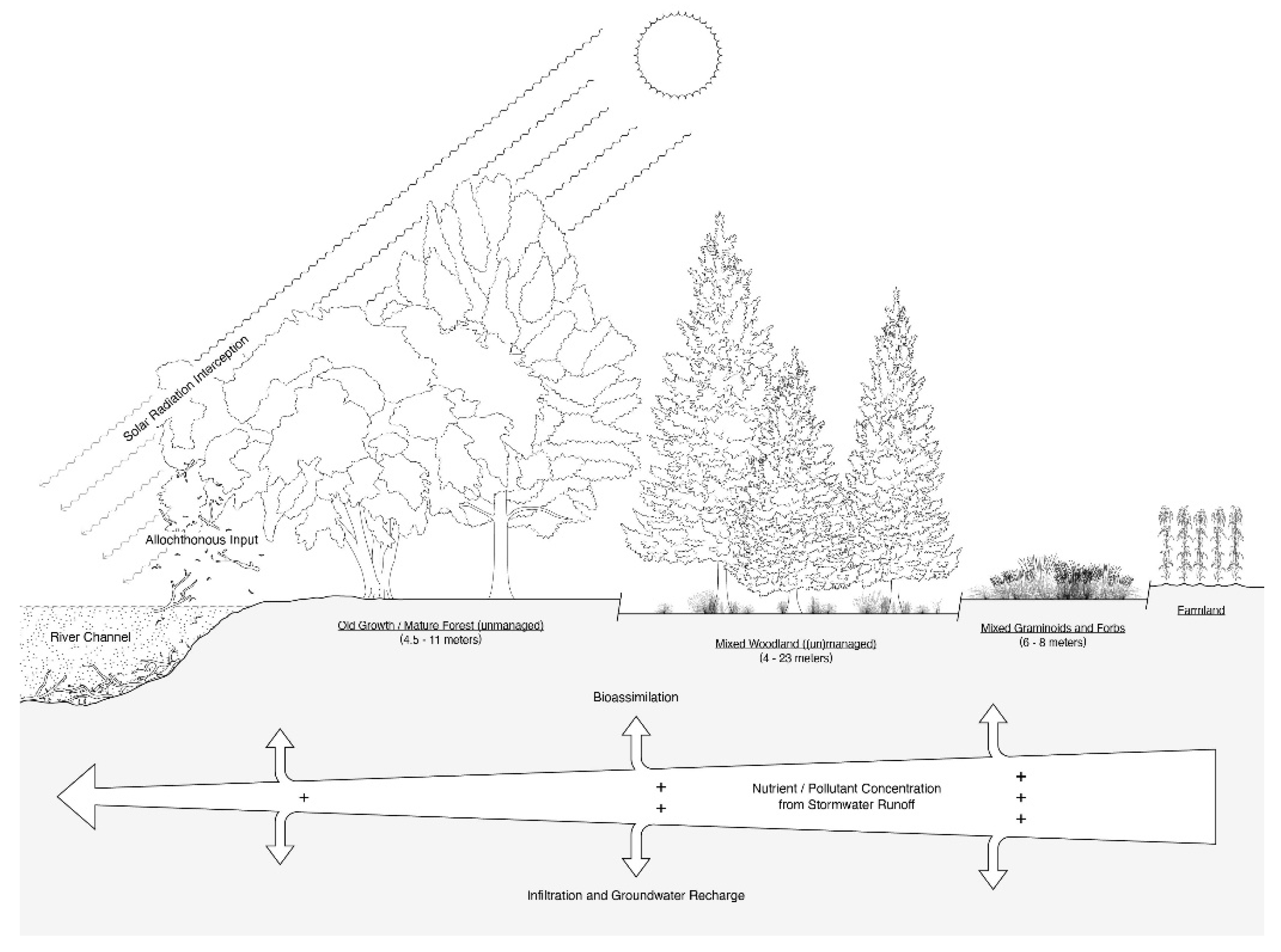
Riparian zones, particularly those with mature forests, supply copious amounts of organic matter and allochthonous input to fuel food-web dynamics in lotic systems (Figure 1). Forests provide an abundant supply of woody debris into rivers, which trap sediments, fine and coarse particulate organic matter, and silt, forming habitats and microsites for aquatic macroinvertebrates and fish [38,39]. Coarse particulate organic matter and fine particulate organic matter are the nutrient sources for detritivores and shredders, which in turn become profitable foraging resources for predatory vertebrates [40,41]. Through decomposition, microbial biofilms growth on woody debris yields dissolved and suspended organic matter [42], which is critical for buffering pH and sequestrating heavy metals [17].
Often overlooked or undervalued, the biphasic life histories of many organisms drive aquatic-upland reciprocal energy and nutrient subsidies, highlighting an inextricable connection of the riparian zone to the river itself [43]. Shifting trophic dynamics from allochthonous to autochthonous production and replacement of specialist feeding guilds (i.e., insectivores, predators) with generalist grazers has been documented after riparian zones have been harvested or otherwise degraded [44,45,46]. The ultimate consequences of such trophic shifts will likely lead to biotic homogenization where the species turnover and functional diversity of aquatic biodiversity from headwaters to lower reaches attenuate along the river continuum [47].
3.2. Critical Habitat, Channel Stabilization, and Nonpoint-Source Pollution Mitigation
Riparian vegetation supplies particulate organic matter in the form of leaf litter and woody debris of variable sizes and decay classes that structure geomorphology and habitat complexity of the aquatic core-forming microsites and refugia for aquatic fauna [17,40,41]. Woody debris resists erosive water currents and redistributes the flow throughout the riverbed resulting in mosaic patterns of erosion and alluvial depositions along river corridors, which further contribute to habitat heterogeneity [3,23]. Deep-water pools formed by debris dams provide critical habitats for spawning and refugia during low-flow seasons [48]. Further, the abundance of large within-stream woody debris is positively associated with turtle density, as it provides critical thermoregulatory sites [49,50].
By intercepting precipitation and slowing surface runoff, riparian buffers filter silt and sediments, heavy metals, agrochemicals, organic wastes, and pathogens, thereby preventing these contaminants from reaching the aquatic core or groundwater [17,19,39,51]. These buffering functions become crucial in urban and agricultural landscapes where nonpoint-source pollution via surface runoff intensifies during rainstorms [51,52]. The root masses of riparian vegetation assist in maintaining the physical structure of soil and reducing soil erosion [17,39]. Decelerated surface runoff enhances groundwater recharge through the riparian soils, even during storm surges [17,53]. Water quality metrics of buffered aquatic systems are more stable than unbuffered systems. For instance, enhanced siltation elevated peak discharge velocities, and channel incision was reported in unbuffered rivers. In contrast, buffered rivers contained the highest volumes of riverbed woody debris, lower sand/slit content, and reduced river discharge, as well as lowered fecal coliform and nutrient concentrations [54,55].
Riparian buffers intercept sedimentation and prevent the loss of interstitial spaces of stream beds, which represent critical habitat for aquatic organisms [31,53,56]. Buffered streams support a diverse aquatic macroinvertebrate community, including environmentally sensitive taxa [54]. In contrast, freshwater turtles inhabiting streams without adequate riparian buffering, particularly those dissecting urban landscapes, exhibit skewed sex ratios and age structures, reduced juvenile recruitment, heightened incidental mortality, and subsidized predation [56,57].
3.3. Climate Change Resistance and Resilience
Riparian zones are both spatially and temporally dynamic and stochastic; as such, riparian biota has evolved life-history strategies and adaptations under environmental variations, which may make them either more resilient or resistant to climate change [5]. Riparian vegetation exhibits a wide array of adaptive morphological and physiological traits—heterophylly (production of variable leaf forms in response to environmental conditions), heteroblasty (abrupt morphological changes in the ontogenetic development), variable-depth root systems, propagule dormancy, and persistence under variable disturbances (flooding, fluvial, fire) and soil conditions (increased salinity)—that confer resilience to extreme climates [5]. Riparian buffers create spatial connectivity across lateral, longitudinal, and vertical dimensions, which provides multiple pathways for species migrations in response to climate shifts [3,58,59]. Additionally, riparian buffers form climate envelopes with high humidity and thermal stability that function as climate refugia [42]. For instance, large trees typical of intact riparian zones create a continuous canopy, which intercepts solar radiation and regulates stream thermal properties [55]. Indeed, harvesting riverbank vegetation has often resulted in elevated average and maximum water temperatures, increased diel fluctuations and incidences of thermal extremes, and erratic disruptions in seasonal thermal regimens [55,60].
4. Threats and Conservation Challenges
Streams and rivers are among the most imperiled habitats in the United States, as well as across the world [58,59,61]. The current estimates for the riparian-zone surface area of the United States range from 15–50 million hectares, of which >90% are degraded [29,62]. There is growing anthropogenic pressure on riverine ecosystems. In the conterminous United States, a significant proportion of the population dwells within 1-km of a river. Nevertheless, only 2% of stream reaches receive riparian protection [62]. Riparian protection remains uneven across the United States. For instance, compared to eastern North America or the Great Plains, riparian zones of the western United States receive enhanced protection where federal land stewardship ensures appreciable conservation attention. Nationwide, ~480,000 km of rivers exhibit degraded water quality, with impaired riparian buffering being at least partly responsible. Impaired riparian systems experience increased solar incidence, dry microclimatic conditions, and lack of environmental complexity, making them unfit for native wildlife, with the exception of a handful of urban exploiters, urban-adapted human commensals, and invasive species [63].
4.1. Anthropogenic Land-Cover Changes and River Modifications
As ecosystem functions of riparian zones rely heavily on fluvial processes, anthropocentric alterations fundamentally influence riparian dynamics [36]. To facilitate navigation, irrigation, and mitigate threats of catastrophic flooding, rivers have undergone drastic modifications with channelization, diversion, and impoundment, which impacts the riparian zone [36,64,65]. In the United States, there are over 2 million dams that influence nearly 90% of regional drainage basins, disrupting both longitudinal and lateral connectivity [66]. For example, permanent upstream floodplain inundation, downstream sediment and nutrient deprivation, damped hydrologic variability, and downstream peak flow attenuation lead to major modifications in the riparian structure and function [29,63]. Dams also impede downstream hydrochory and plant propagule recruitment, which subsequently suppresses riparian vegetation [67,68].
Channelization and bank-stabilization structures sever the connection between the riparian zone and the in-stream habitats, which prevents recruitment of riparian vegetation, disrupts the riparian microhabitat structure, lowers the riparian water table reduces the frequency of overbank flow, and homogenizes shoreline complexity [29,34]. Channelized river corridors lack soft sandy riverbed substrates, sandbars, and large downed wood, which are critical for basking and nesting turtles [64]. Cumulative effects of flow regulation, drainage, and floodplain reclamations transform anastomosing, meandering, and braiding rivers into oversimplified single-tread channels that are severed from riparian zones [65].
Loss of riparian forest cover is particularly notable in anthropogenic landscapes. Biotic homogenization—reduced species turnover across environmental gradients—as a consequence of urbanization was observed across American riverscapes [69,70]. Declining riparian forest cover changes aquatic productivity, such as the prolific growth of exotic species and filamentous algae at the expense of unicellular phytoplankton and non-vascular plants [47,61]. The proliferation of these primary producers neither contributes to food webs nor is exploited by consumers [42,71]. Sporadic changes in seasonal river temperatures resulting from loss of streamside vegetation can negatively impact juvenile development among fish and trigger adverse behaviors, such as untimely migration and phenological mismatches [23,42].
4.2. Recreation-Based Degradation
Given unique aesthetic and scenic values, recreation-based development and activities (whitewater rafting, canoeing, swimming) are often concentrated within riparian zones [72,73]. Proximity to large rivers is among the most demanding landscape features sought by recreational developers as well as amenity migrants for secondary and vacation homes [74,75]. Snag removal and vegetation clearance in the riparian zone to boost recreational and scenic values led to declining diversity among turtles in the northern Midwest [38]. Increased cover of invasive and weedy species is frequently observed in riparian zones impacted by human disturbances [34]. For instance, invasive plant species were found to be absent from river reaches where the surrounding land use was largely undisturbed and exhibited greater complexity in vegetation structure, suggesting that these reaches were more resistant to invasion than reaches, which have experienced degradation [76]. Deliberate introduction of exotic species as landscape ornaments is partly responsible for such biological invasions, at least in the early phases of establishment outside the native range. Riparian corridors are conduits for plant propagules, therefore, riparian zones are particularly vulnerable to plant invasions. Recreational activities enhance the human footprints in riparian zones (e.g., vegetation removal, changes in natural land-cover, simplification of the structural complexity) as well as the fluvial channel (e.g., modifications in the riverbed and bank geomorphology), which can further exacerbate biological invasions [76].
4.3. Resource Overuse
Land development in the riparian zones and floodplains increases the acreage of impervious surfaces, which alter local hydrodynamics and fluvial processes. Riparian forests are high in aboveground biomass, making them particularly susceptible for commercial timber harvesting [1]. Logging or clearcutting within the buffer zone can lead to localized extirpation of riparian specialists [36,48]. Additionally, the paper, pulp, and biofuel industries are also attributed to intensified silvicultural practices within the United States. River corridors have been historically used as effective conveyers of harvested timber. However, to facilitate convenient access to river channels to transport timber to sawmills downstream, riparian vegetation and within-stream wood are often removed [77]. River valleys historically were and continue to be targeted by mineral harvesters, particularly for gold mining, resulting in the clearcutting of riparian vegetation as well as the excavation of streambed substrates [59,73]. Indeed, ecosystems within the riparian zone have been and continue to be set on courses exceeding their historical norms due to anthropogenic influences relating to resource overuse [78].
4.4. Agriculture and Farming
Due to high productivity and soil fertility, riparian habitats across the United States have been converted to row-crop farms nationwide [34]. Moreover, nutrient-rich soils of the riparian zones of large, sluggish rivers and dependable access to water have led to the transformation of such riparian zones into extensive croplands [73]. Given high productivity and access to water and shade, riparian zones attract livestock, which results in overgrazing of riparian vegetation and soil compaction. Setting aside forested buffers for conservation is economically costly, thus farming operations usually encroach the riparian zone, resulting in the conversion of diverse native riparian flora into monocrop stands.
4.5. Challenges in Riparian Conservation
Much of America’s riparian zones are located within privately owned lands. Unfortunately, many of these landowners prioritize profit over sustainability [39,73]. Streams and rivers crossing private lands, especially low-order reaches, receive little to no legislative protection [79]. Land managers of local jurisdictions are often underinformed about riparian functions and biodiversity, hence policies emerging from local authorities are unlikely to generate tangible conservation benefits [52]. Taking riparian lands out of production and re-vegetating buffers are prohibitively expensive, thus, regulations on riparian zones are often resisted by farmers [52,80]. Consequently, riparian conservation policies in the United States are often distilled into politically palatable decisions driven by what private landowners are willing to concede [17].
5. Conservation Efforts
Maintaining intact riparian zones has long been recognized as a crucial element in biodiversity conservation. During the last few decades, riparian-buffer conservation has undergone paradigm shifts where sustainable resource use, endangered species conservation, landscape-scale connectivity, and climate resilience were incorporated into conservation planning [35,63,81].
5.1. Local Scale and Fixed-Width Buffer Zones
Fixed-width buffer zones are the most popular approach to riparian conservation, where decisions were primarily made at the state level, resulting in significant variations in buffer widths (12–52 m) throughout the United States [77]. The site-specific widths for riparian buffers were often estimated based on the maximum height of dominant plant species along the riverbanks. This baseline may be increased based on the aquatic or terrestrial community targeted for conservation. For instance, fish-bearing perennial rivers may have a buffer zone that is twice the height of the tallest tree height (~90–145 m) [82]. The scientific reasoning behind this baseline remains questionable. Nonetheless, the greater buffer-width variations stipulated by different local land managers for protection of the same target species, communities, or ecosystem functions within similar ecoregions is a significant conservation concern [20].
An array of multi-layered vegetation strips has been recommended to mitigate nonpoint-source pollution in streams associated with commercial farmlands (Figure 1). Multi-layered vegetation strips generate a gradient of structural complexity, thereby maintaining multidimensional niches for numerous taxa, including specialist foraging guilds [83]. For example, a vegetation strip dominated by graminoids and herbaceous vegetation has a rapid biomass turnover rate and thus helps restore biologically optimal soil structures. Multi-layered approaches recommended for the United States include a relatively undisturbed old-growth forest (4.5–11 m wide) closest to the stream channel, followed by managed shrub-mixed woodland layer (4–23 m wide), and a graminoid-dominant herbaceous strip mixed with shrubs and scrubs (6–8 m wide) (Figure 1) [3,18,84]. The innermost strip regulates water temperature, enhances habitat complexity and bank stability, and supplies woody debris to the aquatic core while providing critical wildlife habitats for conservation-dependent biota [40,41]. The middl e strip assimilates nutrients, retains fine sediments, and enhances groundwater recharge. The outermost strip acts as a physical barrier to storm-water runoff, reducing erosion and retaining silt, sediment, and agrochemical contaminants. Conservation Buffer Initiative—which stems from the United States Department of Agriculture Conservation Reserve Program—advocates a three-tiered design comprising perennial grasses, two rows of shrubs, and 4–5 rows of mature woody plants for rivers flowing through farmlands [85].
Numerous taxon-specific fixed-with buffer zones have been proposed for wildlife conservation in the United States. For example, buffer zones ranging from 43–290 m have been recommended for the conservation of 95% of herpetofaunal communities [20]. A forested riparian buffer of 150 m is recommended for the conservation of most North American riverine turtles, especially to support their seasonal navigations [38]. This fixed-width buffer becomes untenable for species with complex and wide-ranging life histories. For example, threatened species of riparian turtles may seek refugia as far as 400 m from the river channel they inhabit [38]. Surprisingly, fixed-width buffer zones intended to support macroinvertebrate, fish, and avian species are often smaller than those recommended for herpetofauna, ranging from a minimum of 30 m (macroinvertebrates and fishes) to 175 m (specialized forest birds) [33,86,87]. Similarly, 100–200 m riparian buffers are effective in protecting passerine assemblages and stabilizing populations of area-sensitive songbirds [88]. However, bank stability, protection of water quality, and channel heterogeneity may be achieved by much smaller buffer widths (10–130 m) and may account for >90% of regional vascular floristic richness [35,37]. Nevertheless, large buffers (>100 m) serve multiple purposes, such as mitigation of edge effects on nesting birds while providing habitats for riparian-dependent herpetofauna and small mammals [86,89,90].
Fixed-width buffers gained popularity mostly due to their administrative and operational simplicity but are ineffective to sustain ecosystem functions, metacommunity dynamics, and upland habitat associations of semiaquatic fauna [37,77]. Such singular, generic buffers are often homogenous in habitat structure and incongruent with natural processes, thereby over-simplifying riparian zones’ bio-physical complexity [53]. For instance, in Canadian boreal forests, fixed-width buffers are at least partly responsible for fire suppression. Small-width homogenous buffers take longer to recover from extreme climatic disturbances and are susceptible to species invasions, insect outbreaks, and forest pathogens. Concerning multi-layered buffers, maintaining the prescribed vegetation structure may warrant intensive management interventions, which can be both financially and logistically challenging.
5.2. Watershed Scale and Variable-Width Buffer Zones
Fixed-width buffer zones are readily employable, sufficiently simple for on-ground delineation, and only warrants management interventions at the local scale. In contrast, variable-width buffer zones are more operationally complex and may necessitate land management beyond the local scale yet are effective at reaching desired conservation goals and may generate lasting benefits across broader spatial extents. For instance, watershed-wide buffer zones are compatible with systematic conservation planning designed for both freshwater and terrestrial ecosystems and align with overreaching environmental themes applicable to riverscapes. Resilience to global environmental change, prevention of nonpoint-source pollution, restoration of trophic dynamics and the riverscape continuum, mitigation of “urban stream syndrome,” and augmentation of amphibian and fish biomass in urban and agricultural watersheds can be harmonized with watershed-wide riparian conservation [11,53,64,91]. At the watershed scale, buffered riparian zones support species migrations, assist movements of dispersal-limited species, augment metapopulation dynamics, thereby relieving small, declining, or isolated populations from inbreeding depression, genetic drift, and demographic stochasticity [81,92,93]. For example, streams within extensively forested watersheds yielded enhanced growth and breeding activities, greater body condition, and greater densities of rare salamanders [94]. In anthropocentric landscapes or disturbance-prone watersheds, buffered streams provide refuge for terrestrial source populations [30,31,95]. Watershed-wide riparian buffers established along a north-south orientation or elevation gradients can function as latitudinal migratory corridors aiding poleward or altitudinal range shifts in response to climate change [84].
Buffer zones delineated at the watershed scale restore connectivity integral for rivers and wetlands, including fourfold eco-hydrological dynamics: (1) lateral interactions between aquatic cores and the uplands as well as among different aquatic cores and wetlands; (2) longitudinal dynamics along the river continuum; (3) vertical linkages among the surface water, groundwater and atmosphere; and (4) temporal changes including wetland successions and modifications in channel geomorphology, hydroperiods and flow regimes [11,43,59]. Hence, watershed-wide buffer zones complement biological, hydrological, and geomorphological processes. Effective delineation of watershed-wide buffer zones requires policies that transcend administrative boundaries, focus beyond local scale conservation targets, and warrant participatory management of different jurisdictions and conservation authorities.
5.3. Determinants of Watershed-Scale Buffer Delineation
The magnitude, spatiotemporal extent, and importance of ecological functions of riparian zones depend on both large-scale watershed-wide regional properties and small-scale local habitat characteristics [96]. Thus, the delineation of riparian buffers should be a synergistic product of both local and watershed-scale factors.
Local-scale determinants include channel slope, local topographic relief, riverbank vegetation structure (e.g., stem density, basal area, vegetation successional stages), soil properties, and channel geomorphology [37,53]. Numerous field studies indicated a non-linear relationship between required buffer widths and increasing slope as well as soil erosivity, underpinning the importance of site-specific conditions in delineating buffers [17,23]. Stream order, stream width at bankful discharge, annual discharge regimes, channel dynamics (lateral channel migration and formation of oxbow or scroll lakes) and planform (the quasi-equilibrium channel morphology created by concentration or dissipation of energy and sediment movements), and floodplain complexity should also be considered [58,81,97]. For instance, buffers zones of headwater streams should be sufficiently extensive to protect riverbank seepage formations where the groundwater table approaches the surface. Concerning middle- and higher-order streams, conventional flood-risk assessments [86,87] can be utilized to determine buffer widths, thereby deterring development and industrial farming in flood-prone riparian zones. As private land managers and entrepreneurs are risk aversive, delineating high-risk flood zones as local-scale riparian buffers will carry unintended conservation benefits.
Among watershed-wide determinants—watershed size, basin-wide ecosystem processes, regional geography and climate, current and historical land-use land-cover (the extent of impervious surfaces and modified land-cover types), floodplain characteristics (presence, distribution and types of wetlands), hydrologic connectivity, spatial and temporal distribution of pollutant sources, and types of pollutants—should be accounted when delineating buffer dimensions [11,54,60]. Further, the sociocultural and socioeconomic dimensions cannot be ignored when determining the size and extent of riparian buffers, as local stakeholders must be able to connect the benefits of setting aside tracts of land with their needs and interests [78]. Riparian zones have long been shaped by both human (land-uses and resource extractions) and natural (e.g., climatic, hydrological, geomorphological, fluvial, and biological) processes. Recognizing this multidimensional co-construction will also highlight riparian buffers as an integral component of fluvial ecosystems, which may create a favorable attitude from various sectors (e.g., farmers, agroindustry, policy makers, land-use planners, and land developers) towards riparian-buffer conservation [78]. Thus, watershed-scale buffer delineations must weigh in on anthropocentric uses and values of riparian ecosystems. Both at local and watershed-scale, regional and local wildlife communities that associate riparian buffers as a critical habitat should be factored in as well. Watershed-scale buffer zonation should consider the upland dispersal and migration distance of semiaquatic fauna, which is critical for species with complex life cycles where both breeding migrations and post-natal dispersal occur over long distances [85,95,98,99].
Riparian buffers in managed timberlands should be determined based on harvest regimes, based on the total size of harvested area versus acreage of the unharvested forests in the watershed, harvesting methods, and stand age structure [31,80]. Rivers and wetlands embedded in landscapes with a prolonged land-use past, such as cattle grazing and industrial agriculture, require a lengthy recovering period as well as ample riparian reservations. Thus, land-use legacies, as well as disturbance histories across the watershed, are also critical determinants of buffer zone allocation [54,96]. Legacies resulting from anthropogenic alterations (e.g., riparian timber harvest) induce lasting changes in the entire river corridor (e.g., complete transformation of channel structure and fluvial dynamics), creating alternative states with impoverished ecosystem services [100]. Watershed-scale buffers designed to protect and restore riparian biodiversity and ecosystem functions can be more effective if the lasting effects of historical legacies are recognized.
5.4. Designs for Watershed-Scale Riparian Buffers
Olson et al. [35] proposed watershed-wide buffer conservation, which accounts for lateral and longitudinal linkages of riparian biodiversity as well as riparian-zone ecosystem functions. With the emphasis on cross-ridgeline connectivity to accommodate faunal movements among headwater streams, this conceptual model advocate for wider (200–400 m) buffers. Olson and Burnett [84] designated ridgeline forests with a high density of headwater streams as “linkage corridors” to facilitate cross ridgeline connectivity of local biota. Dispersal aside, ridgeline forests were habitats for endemic species and harbored stable populations of native vertebrates [35,84]. Attributed to this dual function (dispersal and refugia), we proposed that “linkage corridors” be retrofitted into a riparian-buffer network. If strategically designated with ideal spatial configuration within a watershed, “linkage corridors” enhanced metapopulation interactions and assist safe passage during drought-induced movements and provided access to climate refugia in headwaters.
A two-tiered, riparian buffer design was conceptualized for headwaters of the Pacific Northwest, which can reconcile both commercial land-use operations (logging) and wildlife (amphibian) conservation [89]. Referred to as the “spaghetti-meatball approach,” this design comprises non-random alternating configurations of narrow (40–150 m) and wide (400–600 m) buffers [35,92]. The narrow, long buffer strips (“spaghetti”) running alongside streams encompass the moist-mesic riparian microclimates via “stream effect” while protecting strictly-aquatic and bank-dwelling species. When protected areas or other critical and rare habitats (e.g., ephemeral wetlands, fluvial lakes, old-growth stands, tributary junctions) neighbor the river channel, particularly at ridgetops, wider buffers (“meatballs”) can be applied to enhance the structural heterogeneity and resource availability of the riparian environments. Narrow “spaghetti buffers” are sufficient to confer bank stability and filter runoff, thus making them suitable for streams dissecting timberlands and farmlands. High-value conservation targets, such as stream reaches with a high density of microendemic or threatened species, local hotspots of diversity, and bioclimatic refugia can benefit from “meatball buffers”. The “spaghetti-meatball” design also harmonizes economically profitable, yet sustainable land uses with freshwater biodiversity conservation, hence applicable to watershed-scale riverscape conservation.
Riverscapes are spatially complex fluvial systems mosaics of habitat types and environmental gradients, interconnected by dendritic networks with unique spatial configurations and structures that differ markedly from most terrestrial systems and other aquatic systems [11,41]. The spatially heterogeneous structures of the riparian environment (including the floodplains), riparian biotic communities, and matter and energy exchange are particularly important attributes of riverscapes [7,65]. We argue that watershed-wide riparian-buffer conservation will effectively capture all critical attributes of the riverscape.
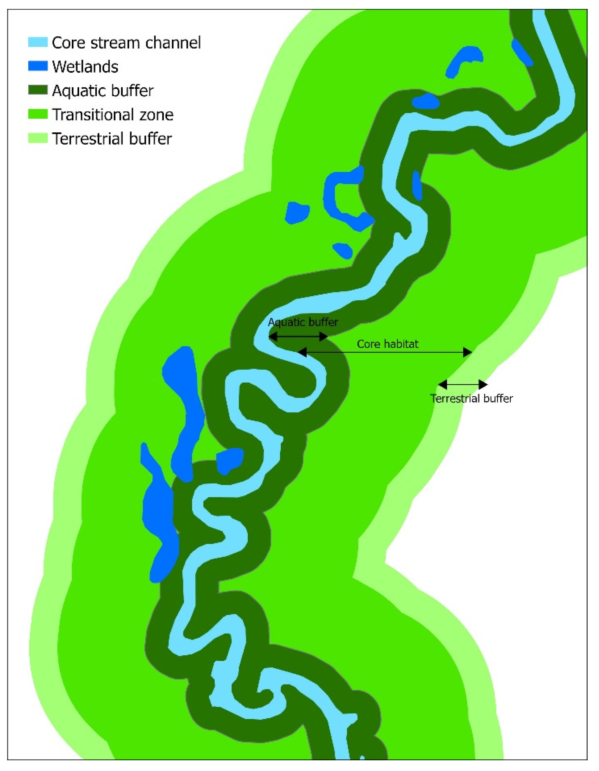
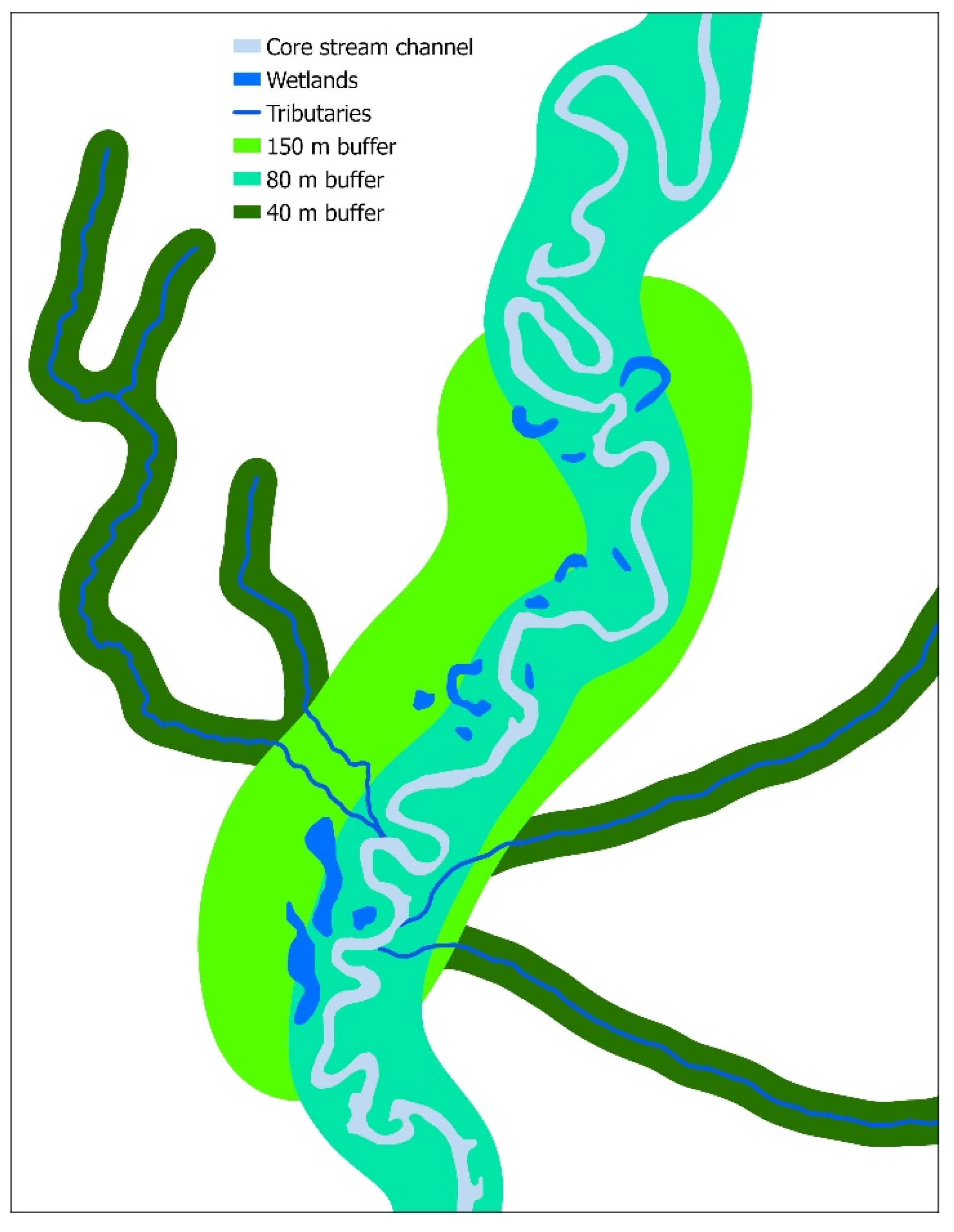
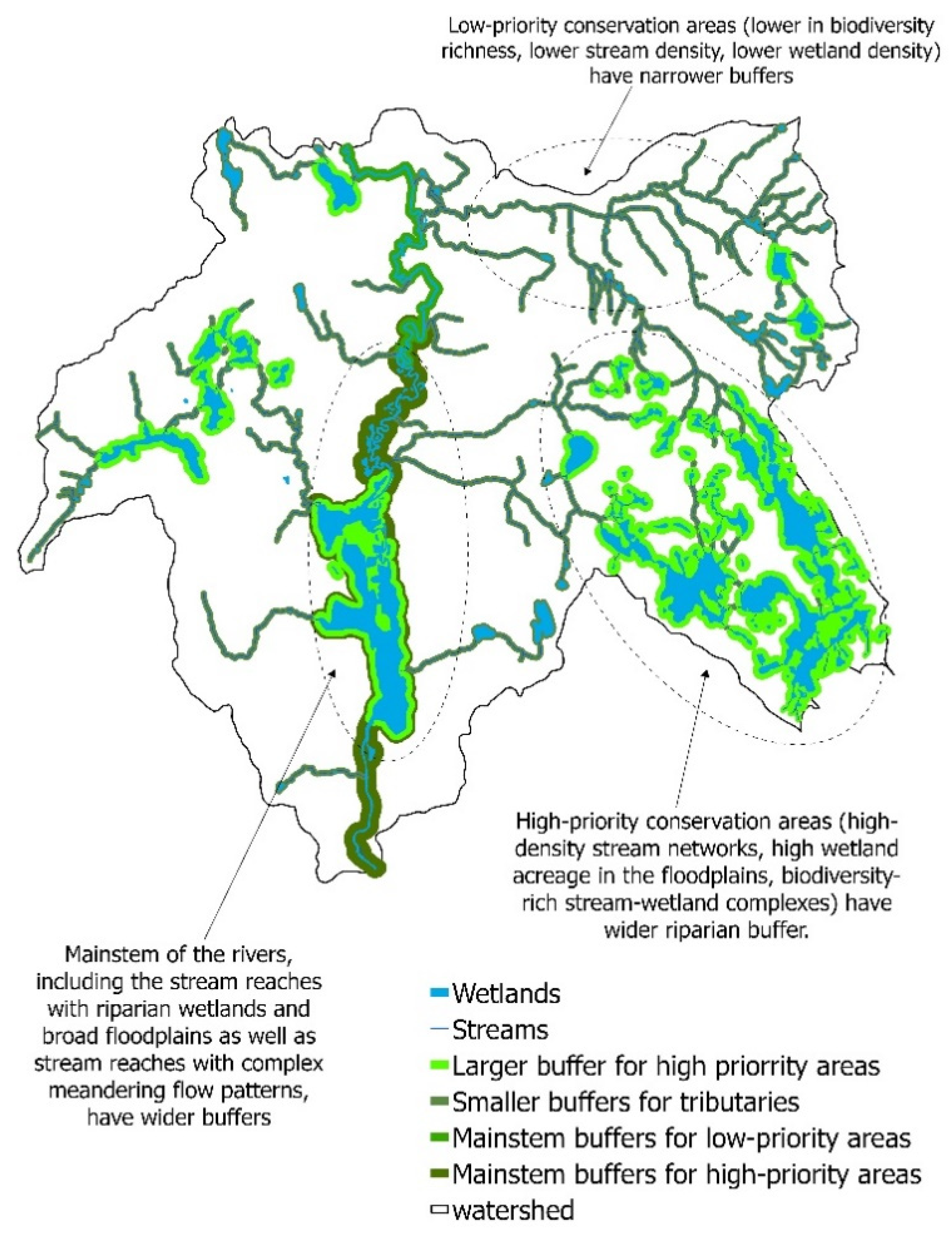
We recommend the implementation of riparian-habitat conservation criteria by Semlitsch and Bodie [25] and Olson et al. [35] to delineate buffers along river channels at the watershed scale, yet caution against abiding by the suggested buffer widths as canonical rules (Figure 2, Figure 3 and Figure 4). Instead, we encourage re-tailoring variable buffer widths based on the spatial configuration of critical riverscape elements (i.e., floodplains, isolated channels) and niche dimensions of riparian-dependent biota of the regional species pool. The riverscape is the template for both between-habitat species turnover (beta diversity) and landscape-scale community diversity (gamma diversity); the latter metrics are prudent biodiversity targets representative of the entire riverscape [81]. Incorporating niche dimensions of riparian biotas, such as the lateral navigation distance of both philopatric and vagile species when delineating riparian zones, will make these buffers more biologically productive [90].
Hereto, we first highlight the immediate riparian zones as both core habitats of the riverscape and keystone structures of the watershed (hereafter, critical riparian core), ergo propose the first tier of buffer delineation throughout the drainage system alongside both main stems and tributaries (both perennial and ephemeral), provisionally extending into the floodplain to envelope riparian wetlands and wetland-obligate communities. These buffers can be locally distended at confluences or to connect the river channel with neighboring wetlands. The first tier should be designed to buffer the stream channel from atmospheric and terrestrial stressors, protect water sources, and enhance habitat associations of riparian and semiaquatic biota. Second, we propose delineating a critical terrestrial core beyond the critical riparian core. This second tier will promote metacommunity dynamics [91] and subdue edge effects [101]. To enhance wildlife permeability, we advise restrictions on both exploitative (subdivision or infrastructure developments, agriculture, grazing, and clearcutting) or non-consumptive (recreational) uses within the critical riparian core while permitting specific land uses (agroforestry, permaculture, forest gardening, selective logging) within the critical terrestrial core.
Greater habitat heterogeneity that satisfies natural and life history requirements of riparian obligates is critical in a watershed-wide buffer delineation. Thus, we advocate the inclusion of multiple landscape elements—hibernacula, climatic refugia, high-quality foraging and nesting grounds, heterogeneous wetland complexes with variable hydroperiods, aquatic habitats that offer complementary resources, and a variety of upland habitats—into both riparian and terrestrial core habitats [93]. Moreover, we contend inclusion of forest remnants, commercial timberlands, silvopastoral systems, traditional farmlands, and restored habitats into the critical terrestrial core to reinvigorate beta and gamma diversity and to refuel metacommunity interactions and ecosystem processes [42,102].
5.5. Habitat Management within Buffer Zones
Harvested riparian zones should be characterized by mixed-aged riparian vegetation, vertical stratification, and variable successional stages, thus providing habitats for both seral and climax communities [48,103]. To promote habitat heterogeneity in the riparian buffers where historical disturbances (flooding, fire, debris flow) are suppressed, sustainable forestry operations based on various shelterwood harvesting methods, such as selective thinning in variable-sized patches, and partial cuts may generate spatial patchiness resembling natural disturbances [36,48,83]. Here, it is imperative to mimic historical disturbance regimes in terms of frequency, duration, magnitude, and spatial patterns [103]. Management decisions should weigh in the system resilience, legacy effects (historical fire regimes and grazing), climate conditions (average precipitation), and susceptibility to extreme events (windstorms, floods). A multi-use approach with regulated timber harvesting and extraction of non-woody products in designated riparian buffers will also harmonize conflicts between conservation authorities and resource users [104].
Riparian timber harvest can be connected to the multi-tiered buffer approach we proposed. No logging should be permitted within the immediate riparian zone adjacent to the stream channel (critical riparian core). Variable and transitional timber management operations forming an environmental gradient with respect to stem density, basal area, canopy closure, stand maturity, and species of interest can be permitted in outer tiers (critical terrestrial core). We urge for minimal use of machinery and motor vehicles, which leads to soil compaction and other disturbances. Availability, diversity, and size of forest-floor cover objects in the riparian buffer are crucial for ameliorating the ill-effects of logging as these cover objects preserve cool, moist microclimatic conditions for forest floor fauna [95]. Thus, we caution against salvage logging or residue removal [35,84]. However, if adequate forest-floor cover exists, some of the logging residuals can be placed alongside banks as microsites to harbor riparian vertebrates and vegetation propagules [96].
To restore longitudinal and lateral connectivity through riparian management, removal of dams, dikes, and levees is imperative to reunite river channels with floodplains and reengineer natural fluvial (meandering, braiding, anastomosing) dynamics [16,96]. Breaching artificial bank stabilization structures such as ripraps also helps restitute surface-to-groundwater movements as well as hydrologic and sediment regimes that are critical for healthy ecosystem functions of riparian zones [16,105]. Dam removal also restores both coarse- and fine-scale geomorphic features, natural flow regimes, and plant successional processes that constitute critical riparian habitats (e.g., floodplain conditions, riparian food webs, plant-community dynamics) and reduce the establishment and persistence of exotic plant species in the riparian zone [16,106,107]. Natural resource managers should estimate site-specific risks of dam removal on riparian zones (e.g., sediment aggradation on riverbanks, habitat homogenization by reducing the variability of bed elevations, biological invasions) for making informed decisions on post-restoration monitoring to detect negative impacts and implement mitigatory measures [97,105]. To improve riparian buffering functions (flood and discharge mitigation, groundwater recharge, and bioremediation), we recommend restoration of floodplain wetlands, which is particularly necessary following dam removal [108]. In impaired (urban and agricultural) watersheds with contaminated runoff, these floodplain wetlands can be an ecologically sound alternative to artificial drainage ponds.
Restoring degraded riparian zones may require the introduction of site-appropriate topsoils and subsoils with adequate soil-particle size distributions and organic matter since plant propagule recruitment, microbial remedial processes, and groundwater movements are functions of soil properties [16]. Introduction of natural cover objects across the riparian buffers in forms of woody debris in variable size and decay classes might be warranted [30,109]. We discourage “landscape manicuring”—removal of downed or standing deadwood for aesthetics and navigation. Spatial arrangement and retention of dead standing trees (snags), rock outcrops, and other vertical geological formations warrant attention as such structures serve as keystone resources for riparian fauna [98]. As degraded riparian zones are species-depauperate and periled with exotic invasions, re-introduction of foundation species (e.g., willows (Salix spp.)) and ecosystem engineers (e.g., American beavers (Castor canadensis)) as well as controlling exotic and invasive species can accelerate recovery with enhanced resilience [82,104,105].
6. Policies and Protection of Riparian Buffers
Numerous United States environmental policies contribute to riparian-buffer conservation [79]. These laws take effect via three mutually nonexclusive avenues: (1) direct acquisition or supporting acquisition of lands and waterways for buffer delineation; (2) restrictions on resource exploitation in riparian environments; and (3) develop environmental standards and guidelines to mitigate water pollution based on buffer-zone management. Herein, we will briefly review a selection of these policies, including their effects and recommendations for enhancing their impact on riparian systems.
Empowered with legislative authority on wetland and riverine buffers, the Clean Water Act (CWA) aims to “restore and maintain the chemical, physical, and biological integrity of the Nation’s waters.” Administered by the Environmental Protection Agency (EPA) and Army Core of Engineering, the CWA recognizes pollution mitigation and provision of wildlife habitats as critical functions of riparian buffers, thus, mandates avoidance and minimization of damage to riparian zones [99,110]. We advocate that CWA’s specifications on total maximum daily load, the maximum amount of a pollutant permissible in a waterbody to maintain acceptable water-quality standards, be leveraged for buffer delineation as a measure against nonpoint-source pollution [53]. We urge the CWA to recognize the riparian buffer as a “critical habitat complementary to the aquatic core” while underscoring the functional nexus between intact riparian zone and biological integrity of aquatic core habitats, thereby advocating restoration and delineation of riparian buffers as a mitigation strategy [25,26].
Administered by Fish and Wildlife Service and National Oceanic and Atmospheric Administration, the Endangered Species Act (ESA) has the potential to secure riparian environments as “critical habitats” for endangered or threatened species [111]. We encourage the inclusion of the “critical habitat” concept into a panoptic “critical riverscape” perspective to encapsulate watershed-wide environmental complexity and functional diversity inherent to riparian zones. For riparian conservation, we propose that the ESA targets umbrella species such as riparian obligates and riparian-dependent species, particularly those characterized by longevity, delayed reproductive maturity, elevated egg/larval mortality, and high sensitivity to anthropogenic disturbances [112].
Mandated by the United States Department of Agriculture (USDA), the National Forest Management Act (NFMA) requires a minimum of 30 m buffer around perennial rivers and lakes and prohibits land uses that impair water quality or fish habitats [34]. As corroborated by our review, the 30-m minimum threshold might suffice conservation of a subset of stream biota (e.g., headwaters) but is insufficient to maintain upland associations of most riparian communities. In lieu of our variable buffer-width standards, we recommend employing local and watershed-scale biophysical determinants to prescribe variables both buffer widths and length to assure watershed-wide continuity.
The National Wild and Scenic Rivers Act (NWSRA, Departments of Interior and Agriculture) aims to preserve “free-flowing” rivers with remarkable ecological and non-consumptive (aesthetic and recreational) values [39,88]. The NWSRA recommends a 400 m riparian buffer along designated rivers flowing through federal lands [113]. Given the conservation potential of these rivers, we suggest remodeling NWSRA to recognize the main stem, tributaries, and floodplains (including floodplain wetlands) of designated rivers collectively as “wild and scenic riverscape corridors” while identifying buffers as “critical life zones” of the entire watershed.
Significant extents of riparian zones in the United States are located within private lands. Further, most land development occurs within local jurisdictions where the decision-making officials are likely uninformed about local biodiversity, ecological principles, or sustainable economic benefits associated with riparian buffers [114]. As such, we highlight the urgency to educate local officials as well as private landowners on watershed-scale buffer designs [73]. To cultivate responsible stewardship among public and local officials, we recommend the introduction of citizen-science projects tailored to generate locale-specific long-term data on riparian biodiversity and ecosystem processes, which provide a scientific basis for decision making [30,115]. We also encourage repurposing citizen science as a communication hub among scientific communities, town officials, and private landowners, particularly to disseminate novel approaches on riparian conservation [43]. To enhance public buy-in, we also recommend the adoption of charismatic or flagship species that symbolize riparian habitats (e.g., river otters (Lontra canadensis) [102].
For watershed-wide riparian conservation to take effect, rewarding land stewards who adopt riparian best management practices are effective and prudent [78]. Administered by the USDA through the Farm Bill, a number of such programs, Conservation Reserve Program, Conservation Easements, and Environmental Quality Incentive Program, have demonstrated success in optimizing conservation potential and environmental benefits in productive agricultural lands [116]. Program participants offset environmentally sensitive lands from production and establish resource-conserving native plant species in exchange for rental payments, tax breaks, and financial and technical support for improving farming operations [85]. Our recommendations herein include educating farmers on agricultural benefits through the use of riparian buffers (e.g., flood and erosion prevention) and remodeling incentive programs for recreational entrepreneurs, the timber industry, and non-timber extraction ventures. Given the multitude of ecosystem functions originating from riparian buffers—groundwater recharge, water-quality enhancement, game species conservation, aesthetic and scenic values—we recommend enhancing incentives through Payments for Ecosystem Services for land stewards participating in riparian-buffer conservation [115].
Policy reforms for watershed-scale riparian-buffer conservation will require a paradigm shift from a conventional reach-based perspective to a more inclusive ecosystem-centered approach tailored for the conservation and restoration of hydrogeomorphological processes with the emphasis on ecological integrity and biological dynamics of rivers [117,118]. Herein, the riparian buffers should allocate more physical space to facilitate channel mobility (e.g., lateral migration, meandering) and seasonal flooding [106,118]. Such policy frameworks not only ensure sustainability and resilience of riverine biodiversity but also mitigate flood and erosion risks. Hydrogeomorphology-influenced policies have been successfully implemented in Europe and Canada [107,117]. These legislative frameworks piggyback on the notion of risk aversion (erosion and flooding) as well as ecological integrity, thus are palatable for multiple stakeholders while affording protection to critical riparian features (e.g., floodplain wetlands) and exclude development and detrimental human activities from the riparian buffers. When implemented at watershed scale, these process-driven conservation actions warrant minimal management interventions over time yet are suitable for enhancing the resilience of lotic ecosystems against global environmental change. In addition, such policies simultaneously address multiple regulatory and conservation goals such as the Habitats and Water Framework Directives of the European Union and the Clean Water and Endangered Species Acts in the US [118].
We advocate that policy reforms recognize riparian buffers not only as “critical life zones” or “core habitats” but also a vital riverine and riverscape elements crucial for biodiversity conservation and ecosystem functions [62,104]. Watershed-scale riparian conservation is appropriate for the conservation of aquatic biota, management of all forms of freshwater habitats, and resolution of competing for anthropocentric interests [11,61]. As inter-state and among-municipality collaborations are pivotal to watershed-scale conservation, we suggest that both federal and state funding mechanisms encourage such cross-jurisdictional partnerships. It is of critical importance that policymakers and scientists are cognizant of the sociocultural dimension in management decisions, as overly simplistic approaches to addressing the perceptions, needs, and interests of local communities are likely to result in conservation impasses [78]. Ultimately, if the knowledge gained through research is unable to be contextualized in a manner, which can be readily assimilated and applied, efforts, which would otherwise preserve and enhance ecosystem structure and function while simultaneously meeting the needs of the local populous are likely doomed to failure. Longitudinal and lateral dimensions inherent to watershed-wide riparian reserves will account not only local species richness (alpha diversity) but also between-habitat species turnover (beta diversity) and landscape-scale diversity (gamma diversity) [34]. We encourage state and federal conservation authorities to use these biodiversity metrics to rationalize conservation-focused decision-making.
7. Conclusive Remarks
We advocate for watershed-scale delineation of variable-width riparian buffers with multiple conservation and management objectives in place of conventional reach-scale, uniform-width approaches. Watershed-wide riparian conservation should draw from a robust ecological knowledge base and conform to the dynamics of riparian-zone ecosystem structure and functions, especially with respect to life and natural histories of local and regional species. Herein, we stress the need to protect diverse arrays of habitats—lentic, lotic, and wetland systems as well as floodplains and upland environments—to preserve landscape-scale heterogeneity, thereby configuring and enhancing connectivity. Riparian buffers are cornerstones for landscape-scale conservation planning and pave a pathway for not only riverscape conservation but also for freshwater protected-area networks. The incongruity between freshwater versus terrestrial protected areas has frequently emerged as a significant conservation challenge, yet little action has been taken to remedy this problem. Riparian buffers define an ecologically meaningful nexus between both stream channels and terrestrial environments, protect and buffer core aquatic habitats, and provide critical resources for biota along the aquatic-terrestrial continuum. Hence, riparian-buffer conservation and management, particularly when implemented at the watershed scale, may have the potential to harmonize disparate conservation goals pertinent to freshwater and terrestrial protected areas.
Author Contributions
T.D.S. developed the concept for this review and provided the overall structure for the manuscript layout and contents, collected relevant literature, subsequently contributed to writing. A.K.D. produced the initial several rounds of drafts. M.P.G. reorganized and rearranged the manuscript layout, tailored it towards a broader audience, and finalized the writing. All authors have read and agreed to the published version of the manuscript.
Funding
This research was funded by the Office of Undergraduate Research at Bridgewater State University.
Acknowledgments
We thank the Office of Undergraduate Research at Bridgewater State University for supporting the student engagement in this research. We also thank Z. Schumacher for his assistance in development of figures used in this manuscript and two anonymous reviewers (R1 and R3) for providing constructive feedback.
Conflicts of Interest
The authors declare no conflict of interest.
References
- Oakley, A.L.; Collins, J.; Everson, L.; Heller, D.; Howerton, J.; Vincent, R. Riparian zones and freshwater wetlands. In Management of Wildlife and Fish Habitats in Forest of Western Oregon and Washington; US Department of Agriculture, Forest Service: Pacific Northwest Region, USA, 1985; pp. 57–80. [Google Scholar]
- Blinn, C.R.; Kilgore, M.A. Riparian management practices: A summary of state guidelines. J. For. 2001, 99, 11–17. [Google Scholar]
- Naiman, R.J.; Decamps, H. The ecology of interfaces: Riparian zones. Annu. Rev. Ecol. Syst. 1997, 28, 621–658. [Google Scholar] [CrossRef] [Green Version]
- Gregory, S.V.; Swanson, F.J.; McKee, W.A.; Cummins, K.W. An ecosystem perspective of riparian zones. Bioscience 1991, 41, 540–551. [Google Scholar] [CrossRef]
- Capon, S.J.; Chambers, L.E.; Mac Nally, R.; Naiman, R.J.; Davies, P.; Marshall, N.; Pittock, J.; Reid, M.; Capon, T.; Douglas, M. Riparian ecosystems in the 21st century: Hotspots for climate change adaptation? Ecosystems 2013, 16, 359–381. [Google Scholar] [CrossRef]
- Erős, T.; Lowe, W.H. The landscape ecology of rivers: From patch-based to spatial network analyses. Curr. Landsc. Ecol. Rep. 2019, 4, 103–112. [Google Scholar] [CrossRef] [Green Version]
- Stanford, J.A.; Alexander, L.C.; Whited, D.C. Chapter 1—Riverscapes. In Methods in Stream Ecology, 3rd ed.; Hauer, F.R., Lamberti, G.A., Eds.; Academic Press: Boston, MA, USA, 2017; Volume 1, pp. 3–19. [Google Scholar] [CrossRef]
- Torgersen, C.E.; Le Pichon, C.; Fullerton, A.H.; Dugdale, S.J.; Duda, J.J.; Giovannini, F.; Tales, É.; Belliard, J.; Branco, P.; Bergeron, N.E. Riverscape approaches in practice: Perspectives and applications. Biol. Rev. 2021. [Google Scholar] [CrossRef] [PubMed]
- Peipoch, M.; Brauns, M.; Hauer, F.R.; Weitere, M.; Valett, H.M. Ecological simplification: Human influences on riverscape complexity. Bioscience 2015, 65, 1057–1065. [Google Scholar] [CrossRef] [Green Version]
- Carbonneau, P.; Fonstad, M.A.; Marcus, W.A.; Dugdale, S.J. Making riverscapes real. Geomorphology 2012, 137, 74–86. [Google Scholar] [CrossRef]
- Fausch, K.D.; Torgersen, C.E.; Baxter, C.V.; Li, H.W. Landscapes to Riverscapes: Bridging the Gap between Research and Conservation of Stream Fishes: A Continuous View of the River is Needed to Understand How Processes Interacting among Scales Set the Context for Stream Fishes and Their Habitat. Bioscience 2002, 52, 483–498. [Google Scholar] [CrossRef] [Green Version]
- Benda, L.; Poff, N.L.; Miller, D.; Dunne, T.; Reeves, G.; Pess, G.; Pollock, M. The Network Dynamics Hypothesis: How Channel Networks Structure Riverine Habitats. Bioscience 2004, 54, 413–427. [Google Scholar] [CrossRef] [Green Version]
- Thorp, J.H.; Thoms, M.C.; Delong, M.D. The riverine ecosystem synthesis: Biocomplexity in river networks across space and time. River Res. Appl. 2006, 22, 123–147. [Google Scholar] [CrossRef]
- Davis, C.D.; Epps, C.W.; Flitcroft, R.L.; Banks, M.A. Refining and defining riverscape genetics: How rivers influence population genetic structure. Wiley Interdiscip. Rev. Water 2018, 5, e1269. [Google Scholar] [CrossRef] [Green Version]
- Sabo, J.L.; Sponseller, R.; Dixon, M.; Gade, K.; Harms, T.; Heffernan, J.; Jani, A.; Katz, G.; Soykan, C.; Watts, J. Riparian zones increase regional species richness by harboring different, not more, species. Ecology 2005, 86, 56–62. [Google Scholar] [CrossRef]
- Shafroth, P.B.; Friedman, J.M.; Auble, G.T.; Scott, M.L.; Braatne, J.H. Potential Responses of Riparian Vegetation to Dam Removal: Dam removal generally causes changes to aspects of the physical environment that influence the establishment and growth of riparian vegetation. Bioscience 2002, 52, 703–712. [Google Scholar] [CrossRef] [Green Version]
- Castelle, A.J.; Johnson, A.; Conolly, C. Wetland and stream buffer size requirements—A review. J. Environ. Qual. 1994, 23, 878–882. [Google Scholar] [CrossRef] [Green Version]
- Anbumozhi, V.; Radhakrishnan, J.; Yamaji, E. Impact of riparian buffer zones on water quality and associated management considerations. Ecol. Eng. 2005, 24, 517–523. [Google Scholar] [CrossRef]
- Vidon, P.; Allan, C.; Burns, D.; Duval, T.P.; Gurwick, N.; Inamdar, S.; Lowrance, R.; Okay, J.; Scott, D.; Sebestyen, S. Hot spots and hot moments in riparian zones: Potential for improved water quality management. J. Am. Water Resour. Assoc. 2010, 46, 278–298. [Google Scholar] [CrossRef]
- Marczak, L.B.; Sakamaki, T.; Turvey, S.L.; Deguise, I.; Wood, S.L.; Richardson, J.S. Are forested buffers an effective conservation strategy for riparian fauna? An assessment using meta-analysis. Ecol. Appl. 2010, 20, 126–134. [Google Scholar] [CrossRef] [PubMed]
- Lee, P.; Smyth, C.; Boutin, S. Quantitative review of riparian buffer width guidelines from Canada and the United States. J. Environ. Manag. 2004, 70, 165–180. [Google Scholar] [CrossRef] [PubMed]
- Noon, B.R.; Blakesley, J.A. Conservation of the northern spotted owl under the Northwest Forest Plan. Conserv. Biol. 2006, 20, 288–296. [Google Scholar] [CrossRef] [PubMed]
- Richardson, J.S.; Taylor, E.; Schluter, D.; Pearson, M.; Hatfield, T. Do riparian zones qualify as critical habitat for endangered freshwater fishes? Can. J. Fish Aquat. Sci. 2010, 67, 1197–1204. [Google Scholar] [CrossRef] [Green Version]
- Odum, E.P. Ecological Importance of the Riparian Zone; General Technical Report WO-US; Department of Agriculture, Forest Service: Washington, D.C., USA, 1979.
- Semlitsch, R.D.; Bodie, J.R. Biological criteria for buffer zones around wetlands and riparian habitats for amphibians and reptiles. Conserv. Biol. 2003, 17, 1219–1228. [Google Scholar] [CrossRef] [Green Version]
- Surasinghe, T.D.; Baldwin, R.F. Importance of riparian forest buffers in conservation of stream biodiversity: Responses to land uses by stream-associated salamanders across two southeastern temperate ecoregions. J. Herpetol. 2015, 49, 83–94. [Google Scholar] [CrossRef]
- Baldwin, R.F.; Demaynadier, P.G. Assessing threats to pool-breeding amphibian habitat in an urbanizing landscape. Biol. Conserv. 2009, 142, 1628–1638. [Google Scholar] [CrossRef]
- Raedeke, K. Streamside Management: Riparian Wildlife and Forest Interactions; Contribution Number 59; Institute of Forest Resources, University of Washington: Seatle, WA, USA, 1989. [Google Scholar]
- National Research Council; Committee on Riparian Zone Functioning and Strategies for Management; Water Science and Technology Board; Board on Environmental Studies and Toxicology; Division on Earth and Life Studies. Riparian Areas: Functions and Strategies for Management; National Academies Press: Washington, DC, USA, 2002. [Google Scholar]
- Lindenmayer, D.; Hobbs, R.J.; Montague-Drake, R.; Alexandra, J.; Bennett, A.; Burgman, M.; Cale, P.; Calhoun, A.; Cramer, V.; Cullen, P.; et al. A checklist for ecological management of landscapes for conservation. Ecol. Lett. 2008, 11, 78–91. [Google Scholar] [CrossRef] [PubMed]
- de Maynadier, P.G.; Hunter, M.L. The relationship between forest management and amphibian ecology: A review of the North American literature. Environ. Rev. 1995, 3, 230–261. [Google Scholar] [CrossRef]
- O’Keefe, J.M.; Loeb, S.C.; Gerard, P.D.; Lanham, J.D. Effects of riparian buffer width on activity and detection of common bats in the southern Appalachian Mountains. Wildl. Soc. Bull. 2013, 37, 319–326. [Google Scholar] [CrossRef]
- Darveau, M.; Beauchesne, P.; Belanger, L.; Huot, J.; Larue, P. Riparian forest strips as habitat for breeding birds in boreal forest. J. Wildl. Manag. 1995, 59, 67–78. [Google Scholar] [CrossRef]
- Knopf, F.L.; Johnson, R.R.; Rich, T.; Samson, F.B.; Szaro, R.C. Conservation of riparian ecosystems in the United States. Wilson Bull. 1988, 100, 272–284. [Google Scholar]
- Olson, D.H.; Anderson, P.D.; Frissell, C.A.; Welsh, H.H.; Bradford, D.F. Biodiversity management approaches for stream–riparian areas: Perspectives for Pacific Northwest headwater forests, microclimates, and amphibians. Ecol. Manag. 2007, 246, 81–107. [Google Scholar] [CrossRef]
- Kuglerová, L.; Ågren, A.; Jansson, R.; Laudon, H. Towards optimizing riparian buffer zones: Ecological and biogeochemical implications for forest management. Ecol. Manag. 2014, 334, 74–84. [Google Scholar] [CrossRef]
- Spackman, S.C.; Hughes, J.W. Assessment of minimum stream corridor width for biological conservation: Species richness and distribution along mid-order streams in Vermont, USA. Biol. Conserv. 1995, 71, 325–332. [Google Scholar] [CrossRef]
- Bodie, J. Stream and riparian management for freshwater turtles. J. Environ. Manag. 2001, 62, 443–455. [Google Scholar] [CrossRef] [PubMed]
- Lovell, S.T.; Sullivan, W.C. Environmental benefits of conservation buffers in the United States: Evidence, promise, and open questions. Agric. Ecosyst. Environ. 2006, 112, 249–260. [Google Scholar] [CrossRef]
- Allan, J.D.; Castillo, M.M. Stream Ecology: Structure and Function of Running Waters; Springer: Dordrecht, The Netherlands, 2007. [Google Scholar]
- Allan, J.D. Landscapes and riverscapes: The influence of land use on stream ecosystems. Annu. Rev. Ecol. Evol. Syst. 2004, 35, 257–284. [Google Scholar] [CrossRef] [Green Version]
- Pusey, B.J.; Arthington, A.H. Importance of the riparian zone to the conservation and management of freshwater fish: A review. Mar. Freshw. Res. 2003, 54, 1–16. [Google Scholar] [CrossRef] [Green Version]
- Ekness, P.; Randhir, T. Effects of riparian areas, stream order, and land use disturbance on watershed-scale habitat potential: An ecohydrologic approach to policy. J. Am. Water Resour. Assoc. 2007, 43, 1468–1482. [Google Scholar] [CrossRef]
- Warren, D.R.; Keeton, W.S.; Kiffney, P.M.; Kaylor, M.J.; Bechtold, H.A.; Magee, J. Changing forests—Changing streams: Riparian forest stand development and ecosystem function in temperate headwaters. Ecosphere 2016, 7, e01435. [Google Scholar] [CrossRef]
- Finlay, J.C. Stream size and human influences on ecosystem production in river networks. Ecosphere 2011, 2, art87. [Google Scholar] [CrossRef]
- Lobón-Cerviá, J.; Mazzoni, R.; Rezende, C.F. Effects of riparian forest removal on the trophic dynamics of a Neotropical stream fish assemblage. J. Fish Biol. 2016, 89, 50–64. [Google Scholar] [CrossRef] [PubMed] [Green Version]
- Lorion, C.M.; Kennedy, B.P. Riparian forest buffers mitigate the effects of deforestation on fish assemblages in tropical headwater streams. Ecol. Appl. 2009, 19, 468–479. [Google Scholar] [CrossRef] [PubMed]
- Broadmeadow, S.; Nisbet, T. The effects of riparian forest management on the freshwater environment: A literature review of best management practice. Hydrol. Earth Syst. Sci. Discuss. 2004, 8, 286–305. [Google Scholar] [CrossRef]
- Pitt, A.L.; Nickerson, M.A. Reassessment of the Turtle Community in the North Fork of White River, Ozark County, Missouri. Copeia 2012, 2012, 367–374. [Google Scholar] [CrossRef]
- Brown, G.P.; Weatherhead, P.J. Thermal ecology and sexual size dimorphism in northern water snakes, Nerodia sipedon. Ecol. Monogr. 2000, 70, 311–330. [Google Scholar] [CrossRef]
- Mcelfish, J.; James, M.; Kihslinger, R.; Nichols, S. Setting Buffer sizes for Wetlands. Nat. Wetl. Newsl. 2008, 30, 6–17. [Google Scholar]
- Hickey, M.B.C.; Doran, B. A review of the efficiency of buffer strips for the maintenance and enhancement of riparian ecosystems. Water Qual. Res. J. 2004, 39, 311–317. [Google Scholar] [CrossRef]
- Osborne, L.L.; Kovacic, D.A. Riparian vegetated buffer strips in water-quality restoration and stream management. Freshw. Biol. 1993, 29, 243–258. [Google Scholar] [CrossRef]
- Muenz, T.K.; Golladay, S.W.; Vellidis, G.; Smith, L.L. Stream buffer effectiveness in an agriculturally influenced area, southwestern Georgia: Responses of water quality, macroinvertebrates, and amphibians. J. Environ. Qual. 2006, 35, 1924–1938. [Google Scholar] [CrossRef] [Green Version]
- Wilkerson, E.; Hagan, J.M.; Siegel, D.; Whitman, A.A. The effectiveness of different buffer widths for protecting headwater stream temperature in Maine. Science 2006, 52, 221–231. [Google Scholar]
- Roberts, H.P.; Jones, M.T.; Willey, L.L.; Akre, T.S.B.; Sievert, P.R.; de Maynadier, P.; Gipe, K.D.; Johnson, G.; Kleopfer, J.; Marchand, M.; et al. Large-scale collaboration reveals landscape-level effects of land-use on turtle demography. Glob. Ecol. Conserv. 2021, 30, e01759. [Google Scholar] [CrossRef]
- Marchand, M.N.; Litvaitis, J.A. Effects of habitat features and landscape composition on the population structure of a common aquatic turtle in a region undergoing rapid development. Conserv. Biol. 2004, 18, 758–767. [Google Scholar] [CrossRef]
- Abell, R. Conservation biology for the biodiversity crisis: A freshwater follow-up. Conserv. Biol. 2002, 16, 1435–1437. [Google Scholar] [CrossRef] [Green Version]
- Brinson, M.M.; Malvarez, A.I. Temperate freshwater wetlands: Types, status, and threats. Environ. Conserv. 2002, 29, 115–133. [Google Scholar] [CrossRef]
- Sinokrot, B.A.; Stefan, H.G. Stream temperature dynamics: Measurements and modeling. Water Resour. Res. 1993, 29, 2299–2312. [Google Scholar] [CrossRef]
- Dudgeon, D.; Arthington, A.H.; Gessner, M.O.; Kawabata, Z.I.; Knowler, D.J.; Leveque, C.; Naiman, R.J.; Prieur-Richard, A.H.; Soto, D.; Stiassny, M.L.J.; et al. Freshwater biodiversity: Importance, threats, status and conservation challenges. Biol. Rev. 2006, 81, 163–182. [Google Scholar] [CrossRef] [PubMed]
- Naiman, R.J.; Decamps, H.; Pollock, M. The role of riparian corridors in maintaining regional biodiversity. Ecol. Appl. 1993, 3, 209–212. [Google Scholar] [CrossRef]
- Hunt, S.D.; Guzy, J.C.; Price, S.J.; Halstead, B.J.; Eskew, E.A.; Dorcas, M.E. Responses of riparian reptile communities to damming and urbanization. Biol. Conserv. 2013, 157, 277–284. [Google Scholar] [CrossRef]
- Sterrett, S.; Smith, L.; Golladay, S.; Schweitzer, S.; Maerz, J. The conservation implications of riparian land use on river turtles. Anim. Conserv. 2010, 14, 38–46. [Google Scholar] [CrossRef]
- Ward, J.V. Riverine landscapes: Biodiversity patterns, disturbance regimes, and aquatic conservation. Biol. Conserv. 1998, 83, 269–278. [Google Scholar] [CrossRef]
- US Army Corps of Engineers. National Inventory of Dams; USACE, NID, USA, 2013. Available online: https://nid.usace.army.mil/#/ (accessed on 1 December 2021).
- Poff, N.L.; Hart, D.D. How Dams Vary and Why It Matters for the Emerging Science of Dam Removal: An ecological classification of dams is needed to characterize how the tremendous variation in the size, operational mode, age, and number of dams in a river basin influences the potential for restoring regulated rivers via dam removal. AIBS Bull. 2002, 52, 659–668. [Google Scholar]
- Bednarek, A.T. Undamming rivers: A review of the ecological impacts of dam removal. Environ. Manag. 2001, 27, 803–814. [Google Scholar] [CrossRef] [PubMed]
- McKinney, M.L.; Lockwood, J.L. Biotic homogenization: A sequential and selective process. In Biotic Homogenization; Springer: Boston, MA, USA, 2001; pp. 1–17. [Google Scholar]
- Scott, M.C. Winners and losers among stream fishes in relation to land use legacies and urban development in the southeastern US. Biol. Conserv. 2006, 127, 301–309. [Google Scholar] [CrossRef]
- Scott, M.C.; Helfman, G.S. Native invasions, homogenization, and the mismeasure of integrity of fish assemblages. Fisheries 2001, 26, 6–15. [Google Scholar] [CrossRef]
- Woolmer, G.; Trombulak, S.C.; Ray, J.C.; Doran, P.J.; Anderson, M.G.; Baldwin, R.F.; Morgan, A.; Sanderson, E.W. Rescaling the human footprint: A tool for conservation planning at an ecoregional scale. Landsc. Urban Plan 2008, 87, 42–53. [Google Scholar] [CrossRef]
- Keddy, P.A.; Fraser, L.H.; Solomeshch, A.I.; Junk, W.J.; Campbell, D.R.; Arroyo, M.T.; Alho, C.J. Wet and wonderful: The world’s largest wetlands are conservation priorities. Bioscience 2009, 59, 39–51. [Google Scholar] [CrossRef] [Green Version]
- Baldwin, R.F.; Trombulak, S.C.; Baldwin, E.D. Assessing risk of large-scale habitat conversion in lightly settled landscapes. Landsc. Urban Plan 2009, 91, 219–225. [Google Scholar] [CrossRef]
- Marcouiller, D.W.; Clendenning, J.G.; Kedzior, R. Natural amenity-led development and rural planning. J. Plan. Lit. 2002, 16, 515–542. [Google Scholar] [CrossRef]
- Zelnik, I.; Mavrič Klenovšek, V.; Gaberščik, A. Complex undisturbed riparian zones are resistant to colonisation by invasive alien plant species. Water 2020, 12, 345. [Google Scholar] [CrossRef] [Green Version]
- Richardson, J.S.; Naiman, R.J.; Bisson, P.A. How did fixed-width buffers become standard practice for protecting freshwaters and their riparian areas from forest harvest practices? Freshw. Sci. 2012, 31, 232–238. [Google Scholar] [CrossRef] [Green Version]
- Dufour, S.; Rodríguez-González, P.M.; Laslier, M. Tracing the scientific trajectory of riparian vegetation studies: Main topics, approaches and needs in a globally changing world. Sci. Total Environ. 2019, 653, 1168–1185. [Google Scholar] [CrossRef]
- Benke, A.C. A perspective on America’s vanishing streams. J. N. Am. Benthol. Soc. 1990, 9, 77–88. [Google Scholar] [CrossRef]
- Russell, K.R.; Wigley, T.B.; Baughman, W.M.; Hanlin, H.G.; Ford, W.M. Responses of Southeastern Amphibians and Reptiles to Forest Management: A Review. General Technical Report SRS–75; US Department of Agriculture, Forest Service, Southern Research Station: Asheville, NC, USA, 2004; Chapter 27; pp. 319–334.
- Ficetola, G.F.; Padoa-Schioppa, E.; De Bernardi, F. Influence of landscape elements in riparian buffers on the conservation of semiaquatic amphibians. Conserv. Biol. 2009, 23, 114–123. [Google Scholar] [CrossRef]
- Forest Ecosystem Management Assessment Team. Forest Ecosystem Management: An Ecological, Economic, and Social Assessment: Report of the Forest Ecosystem Management Assessment Team; U.S. Government Printing Office: Washington, DC, USA, 1993.
- Maisonneuve, C.; Rioux, S. Importance of riparian habitats for small mammal and herpetofaunal communities in agricultural landscapes of southern Québec. Agric. Ecosyst. Environ. 2001, 83, 165–175. [Google Scholar] [CrossRef]
- Olson, D.H.; Burnett, K.M. Design and management of linkage areas across headwater drainages to conserve biodiversity in forest ecosystems. For. Ecol. Manag. 2009, 258, S117–S126. [Google Scholar] [CrossRef]
- Schultz, R.; Isenhart, T.; Simpkins, W.; Colletti, J. Riparian forest buffers in agroecosystems–lessons learned from the Bear Creek Watershed, central Iowa, USA. Agrofor. Syst. 2004, 61, 35–50. [Google Scholar]
- Apel, H.; Merz, B.; Thieken, A.H. Quantification of uncertainties in flood risk assessments. Int. J. River Basin Manag. 2008, 6, 149–162. [Google Scholar] [CrossRef] [Green Version]
- Winsemius, H.; Van Beek, L.; Jongman, B.; Ward, P.; Bouwman, A. A framework for global river flood risk assessments. Hydrol. Earth Syst. Sci. 2013, 17, 1871–1892. [Google Scholar] [CrossRef] [Green Version]
- Lambert, J.D.; Hannon, S.J. Short-term effects of timber harvest on abundance, territory characteristics, and pairing success of ovenbirds in riparian buffer strips. Auk 2000, 117, 687–698. [Google Scholar] [CrossRef]
- Olson, D.H.; Leirness, J.B.; Cunningham, P.G.; Steel, E.A. Riparian buffers and forest thinning: Effects on headwater vertebrates 10 years after thinning. Ecol. Manag. 2014, 321, 81–93. [Google Scholar] [CrossRef]
- Roe, J.H.; Georges, A. Heterogeneous wetland complexes, buffer zones, and travel corridors: Landscape management for freshwater reptiles. Biol. Conserv. 2007, 135, 67–76. [Google Scholar] [CrossRef]
- Brown, B.L.; Swan, C.M.; Auerbach, D.A.; Grant, E.H.C.; Hitt, N.P.; Maloney, K.O.; Patrick, C. Metacommunity theory as a multispecies, multiscale framework for studying the influence of river network structure on riverine communities and ecosystems. J. N. Am. Benthol. Soc. 2011, 30, 310–327. [Google Scholar] [CrossRef]
- Rundio, D.E.; Olson, D.H. Influence of headwater site conditions and riparian buffers on terrestrial salamander response to forest thinning. Science 2007, 53, 320–330. [Google Scholar]
- Burbrink, F.T.; Phillips, C.A.; Heske, E.J. A riparian zone in southern Illinois as a potential dispersal corridor for reptiles and amphibians. Biol. Conserv. 1998, 86, 107–115. [Google Scholar] [CrossRef]
- Barrett, K.; Price, S.J. Urbanization and stream salamanders: A review, conservation options, and research needs. Freshw. Sci. 2014, 33, 927–940. [Google Scholar] [CrossRef] [Green Version]
- Kluber, M.R.; Olson, D.H.; Puettmann, K.J. Amphibian distributions in riparian and upslope areas and their habitat associations on managed forest landscapes in the Oregon Coast Range. Ecol. Manag. 2008, 256, 529–535. [Google Scholar] [CrossRef]
- Kauffman, J.B.; Beschta, R.L.; Otting, N.; Lytjen, D. An ecological perspective of riparian and stream restoration in the western United States. Fisheries 1997, 22, 12–24. [Google Scholar] [CrossRef]
- Foley, M.M.; Bellmore, J.; O’Connor, J.E.; Duda, J.J.; East, A.E.; Grant, G.; Anderson, C.W.; Bountry, J.A.; Collins, M.J.; Connolly, P.J. Dam removal: Listening in. Water Resour. Res. 2017, 53, 5229–5246. [Google Scholar] [CrossRef]
- Brooks, R.T.; Nislow, K.H.; Lowe, W.H.; Wilson, M.K.; King, D.I. Forest succession and terrestrial–aquatic biodiversity in small forested watersheds: A review of principles, relationships and implications for management. Forestry 2012, 85, 315–328. [Google Scholar] [CrossRef]
- Hough, P.; Robertson, M. Mitigation under Section 404 of the Clean Water Act: Where it comes from, what it means. Wetl. Ecol. Manag. 2009, 17, 15–33. [Google Scholar] [CrossRef] [Green Version]
- Wohl, E. Forgotten Legacies: Understanding and Mitigating Historical Human Alterations of River Corridors. Water Resour. Res. 2019, 55, 5181–5201. [Google Scholar] [CrossRef] [Green Version]
- Stewart, K.J.; Mallik, A.U. Bryophyte responses to microclimatic edge effects across riparian buffers. Ecol. Appl. 2006, 16, 1474–1486. [Google Scholar] [CrossRef]
- Richardson, J.S.; Naiman, R.J.; Swanson, F.J.; Hibbs, D.E. Riparian communities associated with pacific northwest headwater streams: Assemblages, processes, and uniqueness. J. Am. Water Resour. Assoc. 2005, 41, 935–947. [Google Scholar] [CrossRef]
- Naiman, R.J.; Bilby, R.E.; Bisson, P.A. Riparian ecology and management in the Pacific coastal rain forest. Bioscience 2000, 50, 996–1011. [Google Scholar] [CrossRef]
- Nel, J.L.; Roux, D.J.; Abell, R.; Ashton, P.J.; Cowling, R.M.; Higgins, J.V.; Thieme, M.; Viers, J.H. Progress and challenges in freshwater conservation planning. Aquat. Conserv. Mar. Freshw. Ecosyst. 2009, 19, 474–485. [Google Scholar] [CrossRef]
- Tullos, D.D.; Collins, M.J.; Bellmore, J.R.; Bountry, J.A.; Connolly, P.J.; Shafroth, P.B.; Wilcox, A.C. Synthesis of common management concerns associated with dam removal. JAWRA J. Am. Water Resour. Assoc. 2016, 52, 1179–1206. [Google Scholar] [CrossRef]
- Kondolf, G.M. Setting goals in river restoration: When and where can the river “heal itself”. Stream Restor. Dyn. Fluv. Syst. 2011, 194, 29–43. [Google Scholar]
- Ollero, A. Channel changes and floodplain management in the meandering middle Ebro River, Spain. Geomorphology 2010, 117, 247–260. [Google Scholar] [CrossRef]
- Bellmore, J.R.; Pess, G.R.; Duda, J.J.; O’Connor, J.E.; East, A.E.; Foley, M.M.; Wilcox, A.C.; Major, J.J.; Shafroth, P.B.; Morley, S.A.; et al. Conceptualizing Ecological Responses to Dam Removal: If You Remove It, What’s to Come? Bioscience 2019, 69, 26–39. [Google Scholar] [CrossRef] [PubMed] [Green Version]
- Semlitsch, R.D.; Todd, B.D.; Blomquist, S.M.; Calhoun, A.J.K.; Gibbons, J.W.; Gibbs, J.P.; Graeter, G.J.; Harper, E.B.; Hocking, D.J.; Hunter, M.L., Jr.; et al. Effects of Timber Harvest on Amphibian Populations: Understanding Mechanisms from Forest Experiments. Bioscience 2009, 59, 853–862. [Google Scholar] [CrossRef] [Green Version]
- National Research Council. Compensating for Wetland Losses under the Clean Water Act; National Academies Press: Washington, DC, USA, 2001. [Google Scholar]
- Noss, R.F.; O’Connell, M.; Murphy, D.D. The science of Conservation Planning: Habitat Conservation under the Endangered Species Act; Island Press: Washington, DC, USA, 1997. [Google Scholar]
- Jachowski, C.M.B.; Hopkins, W.A. Loss of catchment-wide riparian forest cover is associated with reduced recruitment in a long-lived amphibian. Biol. Conserv. 2018, 220, 215–227. [Google Scholar] [CrossRef]
- Abell, R.; Allan, J.D.; Lehner, B. Unlocking the potential of protected areas for freshwaters. Biol. Conserv. 2007, 134, 48–63. [Google Scholar] [CrossRef]
- Calhoun, A.J.; Miller, N.A.; Klemens, M.W. Conserving pool-breeding amphibians in human-dominated landscapes through local implementation of Best Development Practices. Wetl. Ecol. Manag. 2005, 13, 291–304. [Google Scholar] [CrossRef] [Green Version]
- González, E.; Felipe-Lucia, M.R.; Bourgeois, B.; Boz, B.; Nilsson, C.; Palmer, G.; Sher, A.A. Integrative conservation of riparian zones. Biol. Conserv. 2017, 211, 20–29. [Google Scholar] [CrossRef]
- Teels, B.M.; Rewa, C.A.; Myers, J. Aquatic condition response to riparian buffer establishment. Wildl. Soc. Bull. 2006, 34, 927–935. [Google Scholar] [CrossRef]
- Biron, P.M.; Buffin-Bélanger, T.; Larocque, M.; Choné, G.; Cloutier, C.-A.; Ouellet, M.-A.; Demers, S.; Olsen, T.; Desjarlais, C.; Eyquem, J. Freedom space for rivers: A sustainable management approach to enhance river resilience. Environ. Manag. 2014, 54, 1056–1073. [Google Scholar] [CrossRef] [PubMed] [Green Version]
- Beechie, T.J.; Sear, D.A.; Olden, J.D.; Pess, G.R.; Buffington, J.M.; Moir, H.; Roni, P.; Pollock, M.M. Process-based Principles for Restoring River Ecosystems. Bioscience 2010, 60, 209–222. [Google Scholar] [CrossRef] [Green Version]
Figure 1.
Ecological structure, functions, and multi-tiered delineation of riparian buffers.

Figure 2.
Fixed buffer widths applied to a single mainstem river corridor following multi-tiered buffer widths recommended by Semlitsch and Bodie [25].
Figure 2.
Fixed buffer widths applied to a single mainstem river corridor following multi-tiered buffer widths recommended by Semlitsch and Bodie [25].

Figure 3.
A variation of the Spaghetti-meatball buffer-zone delineation with variable buffer widths as recommended by Olson et al. [35,89] applied to the mainstem river corridor, including the tributaries to the mainstem.

Figure 4.
Variable buffer widths applied to stream channels (mainstem and tributaries) and stream-associated wetlands at the watershed scale. Increased riparian buffer widths are applied to regions with high conservation potential and other critical hydrological or ecological features to protect infertility ecosystem structure and functions.

Publisher’s Note: MDPI stays neutral with regard to jurisdictional claims in published maps and institutional affiliations. |
© 2022 by the authors. Licensee MDPI, Basel, Switzerland. This article is an open access article distributed under the terms and conditions of the Creative Commons Attribution (CC BY) license (https://creativecommons.org/licenses/by/4.0/).
Share and Cite
MDPI and ACS Style
Graziano, M.P.; Deguire, A.K.; Surasinghe, T.D. Riparian Buffers as a Critical Landscape Feature: Insights for Riverscape Conservation and Policy Renovations. Diversity 2022, 14, 172. https://doi.org/10.3390/d14030172
AMA Style
Graziano MP, Deguire AK, Surasinghe TD. Riparian Buffers as a Critical Landscape Feature: Insights for Riverscape Conservation and Policy Renovations. Diversity. 2022; 14(3):172. https://doi.org/10.3390/d14030172
Chicago/Turabian StyleGraziano, Michael P., Amanda K. Deguire, and Thilina D. Surasinghe. 2022. "Riparian Buffers as a Critical Landscape Feature: Insights for Riverscape Conservation and Policy Renovations" Diversity 14, no. 3: 172. https://doi.org/10.3390/d14030172
Note that from the first issue of 2016, this journal uses article numbers instead of page numbers. See further details here.